
[This article was created on 1 September 1997 and updated on 27 July 1998]
This article discusses the origin and location of the original pueblo of Los Angeles, founded on September 4th, 1781 and confirmed on September 4th, 1786. This pueblo deteriorated and a gradual abandonment and move to the present location around the current plaza took place between about 1815 (the year of a major flood) and 1835 (the year Los Angeles was elevated to a ciudad) the precise years not being known.
Contents
1872 Description of the Original Pueblo
1976 Description of the Original Pueblo
Probable Location of the Original Pueblo
Counterpoint
Conclusion
Harlow's Sources
Appendix
Notes
The early history of the city was well described in the first Los Angeles City and County Directory, published in 1872.[1] The relevant portion of the directory is reproduced verbatim below, with the author's comments in footnotes.[2]
Los Angeles CityThe City of Los Angeles was founded on the 4th day of September, 1781, in conformity with the laws of Spain, providing for the settlement and organization of towns (pueblos) or municipal communities. The founders of the town had, mostly, if not all, been soldiers;[3] and, although relieved from active service were entitled to and continued to receive pay and rations during the supremacy of the Spanish Government in California. The settlement consisted of twelve families. One of the settlers was a widower having one child, a daughter, aged eleven years. The others were all married and eight of them had children. The eldest of the settlers was sixty-seven years old, one was fifty-five and three were fifty years of age, and one was forty-two and the others were from nineteen--the youngest, an Indian--to thirty-eight. The average age of the twelve male settlers was thirty-nine and two-thirds years. There were eleven married women. The whole number of children were twenty-three, only three of which were over ten years old. Eleven of the children were boys and twelve were girls. The community numbered in all forty-six souls. Of the twelve men, heads of families, two were Spaniards, two mulattoes, two negros, four Indians, one Chinaman[4] and one half-breed (Indian and negro). Of the women, six were mulattoes and five were Indians. The adults were natives of Lower California, Sonora and Sinaloa, excepting the two Spaniards and the Chinaman.
Each family was furnished from the royal treasury, with two oxen, two mules, two mares, two sheep, two goats, two cows with one calf, one ass and one hoe, and to the community the necessary tools of a cart maker. These articles, inclusive of the live stock, were all charged to the individuals or the community at a price established by the Government and that amount was to be deducted, in small installments, from their pay.
For the town site a parallelogram one hundred varas[5] long by seventy-five in width was laid out. Upon three sides of this twelve were house lots, each forty by twenty varas, excepting the two corner lots, which fronting in part on two sides of the square were of a different figure. One half the remaining side of the parallelogram was open, the other half was for the guard house, royal officers and a granery. The location of this town site was above or northeast of the present Catholic Church site. The guard house and royal building which occupied the west half of the southwestern side of the parallelogram were on the opposite side of Main street from Campbell's store.[6] The four lines of the parallelogram instead of running towards the four cardinal points were about equi distant between these points. An irrigating ditch bringing water from the river passed along to the east of and in the rear of and close to those lots on the southeast corner of the square. Thirty fields for cultivation were also laid out.[7] Twenty-six of these fields contained each forty thousand square varas. They were, with the exception of four, which were three hundred varas by one hundred, two hundred varas square and separated by lanes three varas wide. These fields were located between the river and the irrigating ditch and mostly above a line running direct and nearly east from the located town site to the river. The distance from the irrigating ditch to the river across these fields was upwards of twelve hundred varas. At that time the river ran along by where now stands the houses of Julian Chavis and Elijah Moulton,[8] and the easternmost of these fields were close to the river.
It is evident that when the town was laid out, the bluff bank which in modern times extended from Aliso street up by the Stearns Mill to the toma[9] did not exist, but was made when the river moved near the town.
The surnames of the twelve settlers were Lara, Navarro, Rosas, Mesa, Villavicencio, Banegas, Rosas, Rodriguez, Camero, Quintero, Mereno and Rodriguez.[10] Subsequent to the settlement of the town, the river abandoned its bed and moved to the west side of all the fields and flowed along where the Eagle Mill now stands, and where Alameda street is now located. The old fields were either washed away or covered up with sand by the change of the river bed. In 1825 the river again left its bed and made a new one nearly intermediate between the two preceding ones.
From its settlement the growth of the town was very slow for a period of fifty years. Its growth was dependent upon the natural increase of the settlers by additional soldiers, as they were from time to time relieved from active service and permitted to make the town of Los Angeles their residence.
About 1836 the town (pueblo) was created a city and made the capital of Alta California by act of the Mexican Congress, and the Governor, Don Carlos Carrillo, during his brief administration made it the seat of the Civil Government. After the expulsion of Micheltoreno it again became the seat of Government under the administration of Don Pio Pico, in 1844, and so continued until the emigration, in August, 1846, of the Mexican authorities upon the occupation of California by the United States forces.
The corporate limits of the city extend one Spanish league[11] north, east and west, and one Spanish league and four hundred yards south from the centre of the plaza. The Los Angeles river, originally called the Porciuncula, flows through the city limits, a little east of the centre, in nearly a south course. Nearly all the buildings and inhabitants of the city are upon the west side of the river.
From some undefined cause the growth or extension of the improved or built up part of the city has ever been in a southwesterly direction. Notwithstanding that for a period of fifty years, until 1832, the town was a quasi military post, the able-bodied male population being on the muster rolls and performing guard duty by day and night at the guard house, and field duty whenever circumstances required, the public square and houses around it fell into decay and ruins, while the accession was mostly on the southwest of the original site. This might have been and probably was caused by the change in the bed of the river, the destruction of the agricultural fields and the washing out and leaving the bed of the river so much where the water was taken out, that the water could not be brought into the original ditch, and the inhabitants were forced to make new fields in the neighborhood of what is now San Pedro street. But whatever may have at first impelled that people to extend the town southwesterly, its growth in time past has been and at present is in that direction. . . .
Chapter I of a 1976 book by Harlow[12] provides a more precise description of the founding and location of the original pueblo. The following discussion relies primarily on that description and the sources which Harlow cites (see later).
On April 19th, 1776, Felipe de Neve, Governor of both Californias, was ordered to move from Loreto on the east coast of Baja California to Monterey in Alta California, where he arrived in February, 1777. He was instructed, among other duties, to establish colonies in the new province that would contribute to the support of the province and shorten resupply routes to the north. On his trip north he decided that the land along the Porciúncula (Los Angeles) River was one of only a few places where the land was fertile enough for crops, and water easily available.
Teodoro de Croix, Commandant General of the northern provinces, approved the establishment of pueblos in the southern portion of Alta California in September, 1778, but it wasn't until December 27th, 1779, that he ordered a band of pobladores (settlers) to be raised in the states of Sonora and Sinaloa (on the west coast of Mexico, across the Gulf of California from Baja) to establish a new town on the Porciúncula. Under the command of Capt. Fernando de Rivera y Moncada, previously military commandant at Monterey and now the emissary of Gov. de Neve, a party of fourteen families was raised, and the main body of colonists and seventeen soldiers left Los Alamos, Sonora, on February 2nd, 1781, and trekked north, arriving near mission of San Gabriel of Archangel on August 18th, 1781. They were quarantined a short distance away since they had been exposed to smallpox during their journey, but soon were moved to the site of the new town.
On September 4th de Neve "got together all the colonists who had come for this purpose and he assigned them lands and a townsite on the banks of the river . . . and there, under a guard of a corporal and three soldiers,[13] they founded the town . . . under the name of Our Lady of the Angels of the Porciúcula." Harlow notes that although de Neve was probably at San Gabriel and no doubt selected the home and farm sites, José Argüello, Ensign[14] of the garrison at Santa Barbara, "was commissioned . . . to found the Pueblo de la Reyna de los Angeles and it was founded with all the advantages and opportunities which the situation offered . . . ." The site of the pueblo, and the farm lands on the banks of a river named Porciúcula, were about four leagues[15] northwest of the mission of San Gabriel.[16]
Of the fourteen settlers who made the trip, eleven[17] started the new town. The Padrón (poll) of November 19th, 1781, listing the eleven families with their ages, is given in the panel below.[18]
Padrón of the Original Pueblo on November 19th, 1781
Lara
José Fernanco de, Español, Hombre,
50
María Antonio, India, Mujer, 23
María Juan, Niña,
6
José Julian, Niño, 4
María Faustina, Niña,
2
Navarro
José Antonio, Mestizo, Hombre, 42
María
Regina, Mulata, Mujer, 47
José Eduardo, Niño, 10
José
Clemente, Niño, 9
Mariana, Niña, 4
Rosas
Basilio, Indio, Hombre, 67
María
Manuela, Mulata, Mujer, 43
José Maxímo, Niño, 15
José Carlos, Niño, 12
María Josefa, Niña, 8
Antonio Rosalino, Niño, 7
José Marcelino, Niño, 4
José Esteban, Niño, 2
Mesa
Antonio, Negro, Hombre, 38
María Ana,
Mulata, Mujer, 27
María Paula, Niña, 10
Antonio María,
Niño, 8
Villavicencio
Antonio Clemente, Español, Hombre,
30
María Seferina, India, Mujer, 26
María Antonia, Niña,
8
Vanegas
José, Indio, Hombre, 28
María
Bonifacia, India, Mujer, 20
Cosme Damien, Niño, 1
Rosas
Alejandro, Indio, Hombre, 19
Juana María,
India, Mujer, 20
Rodríguez
Pablo, Indio, Hombre, 25
María
Rosalía, India, 26
María Antonia, Niña, 1
Camero
Manuel, Mulato, Hombre, 30
María
Tomasa, Mulata, Mujer, 24
Quintero
Luis, Negro, Hombre, 55
María Petra,
Mulata, Mujer, 40
María Gertrudis, Niña, 16
María
Concepcíon, Niña, 9
María Tomasa, Niña, 7
María Rafaela, Niña, 6
José Clemente, Niño, 3
Moreno
José, Mulato, Hombre, 22
María
Guadalupe, Mulata, Mujer, 19
Following is a corrected version of the statistics given in the first Los Angeles City and County Directory, quoted earlier, based on this 1781 census:
The settlement consisted of eleven families. The settlers were all married and eight of them had children. The eldest of the settlers was sixty-seven years old, one was fifty-five, one was fifty years, one was forty-two and the others were from nineteen--the youngest, an Indian--to thirty-eight. The average age of the eleven male settlers was thirty-seven years. There were eleven married women. The whole number of children were twenty-two, only three of which were over ten years old. Eleven of the children were boys and eleven were girls. The community numbered in all forty-four souls. Of the eleven men, heads of families, two were Spaniards, two Mulattoes, two Negros, four Indians and one Mestizo. Of the women, six were mulattoes and five were Indians.[19] The adults were natives of Sonora and Sinaloa, excepting the two Spaniards.
To this we add that the average age of all of the family members was 20.
According to the Reglamento é instrucción (Regulations and Instructions) for the government of California issued there as a bando (decree) on March 6th, 1781, each settler was to receive without cost a solar (homesite) and a suerte (tract for farming). He was to be supplied with livestock, tools and seed which were to paid for within five years from his farm products. He was to be paid an annual stipend and receive minimal rations for five years, during which time he would not be taxed.
In return each settler was required to sell his surplus produce only to the presidios (military garrisons) and stay ready for military duty as needed. He had to build a house within three years, and he couldn't mortgage his property which was to be left to his heirs in perpetuity. He had to farm, and to maintain a specified number of animals (but no more than fifty animals of any one kind). He had to help maintain the zanjas, roads and streets, the church and other public buildings.
According to the Los Angeles City and County Directory previously quoted earlier and repeated here:
Each family was furnished from the royal treasury, with two oxen, two mules, two mares, two sheep, two goats, two cows with one calf, one ass and one hoe, and to the community the necessary tools of a cart maker. These articles, inclusive of the live stock, were all charged to the individuals or the community at a price established by the Government and that amount was to be deducted, in small installments, from their pay.
The zanja madre and corrals were completed by October 29th, 1781, and temporary residences of willow branches intertwined with tule grass and roofed with mud were under construction. The adobe homes and public buildings were completed somewhat later. The chapel at the south end of the pueblo was started in 1784 and probably completed by 1789.
On August 14th, then Governor Pedro Fages instructed José Argüello to finalize the allocation of property at the pueblo. On September 4th, 1786, exactly five years after the founding day, the eight remaining settlers[20] and latecomer José Sinoba[21] were put in official possession of their lands by Argüello, witnessed by Vicente Féliz and Roque de Cota, soldiers who had accompanied the settlers on their trip north. On September 18th, Argüello reported the successful completion of his task to Fages.
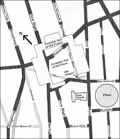
The following discussion of the original pueblo's location relies primarily on Harlow's research and the sources which he cites (see later),[22] supplemented by the 1873 description given earlier and the other descriptions noted below.
The town was located to the west of the river, next to and west of the zanja madre (mother ditch, the settlement's water channel), on slightly elevated land not subject to flooding. It was situated so that the corners were close to the cardinal points of the compass to minimize exposure to the four winds, and had a view of most of the farm lots.
The southeast side of old Upper Main Street (later Spring Street) was said to have formed the southeast side of the old plaza. This is consistent with the location on slightly elevated land, being somewhat away from the slope that rose more sharply towards Fort Moore Hill west of the current Spring Street.
The south corner of the old plaza was said to lie at the corner of Upper Main and Marchessault Streets, a point now in El Pueblo Parking Lot No. 2, as is the stretch of Upper Main noted above and a stretch of old Short Street (later old Sunset Boulevard) which would have crossed the western corner of the old plaza. Given the measurements of the old plaza, its northwest side would have followed a portion of New High Street that has now disappeared. This area has never been excavated.[23]
One of the sources for this location is the centennial history of the city written in 1876:[24]
The location of the public square would nearly correspond to the following lines: The southeast corner of Upper Main and Marchessault streets for the southern or southeastern corner of the square; the east line of Upper Main street, from the above named corner, one hundred varas in a northerly direction, for the east line of the square; the eastern line of New High street for the western line of the square; and the northern line of Marchessault street for the southern line of the square.
The plaza was open on the southwest side where the public buildings (granery, royal houses, guard house and chapel) were located. The homesites were located along the other three sides. The plaza measured about 75 varas wide on the southwest and northeast sides and 100 on the other sides (about 206 feet by 275).[25] Each homesite was twenty varas in width and forty in depth (55 feet by 110).
The chapel measured about 6 varas by 20 (16 feet by 55). The site of the chapel probably lies slightly north of the location of the present-day plaza church, at the south end of the southwest (open) side of the old plaza. However, there is an indication that it may have been located west of the original pueblo, up the slope, at what became the southeast corner of Broadway and Sunset. A paper read by an authority of the Catholic Church in 1890 stated that "Where Buena Vista street [Broadway] is now open north on the hill, there stood a chapel from the year 1784 until 1812, where a Franciscan friar from San Gabriel said mass every Sunday and on holy days, for the accommodation of the settlers and their families."[26]
The probable locations of the old pueblo and its chapel are shown to scale on the map below, in relation to the current plaza and church which are shaded medium grey. On this map, streets which no longer exist are also shown in grey, and/or labeled in italics.
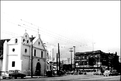
The older photograph below looks north from the current plaza, across Main Street at its interstection with Republic, towards the location of the old pueblo. The original pueblo stood a little north of the present church.
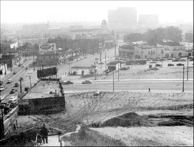
The older photograph below looks southeast from Fort Moore Hill towards the location of the old pueblo. A later cuartel (and possibly the old chapel) stood about where the gas station appears, in the center left of the picture, at the south corner of Broadway and Sunset. The old plaza was located approximately a block southeast of that corner.
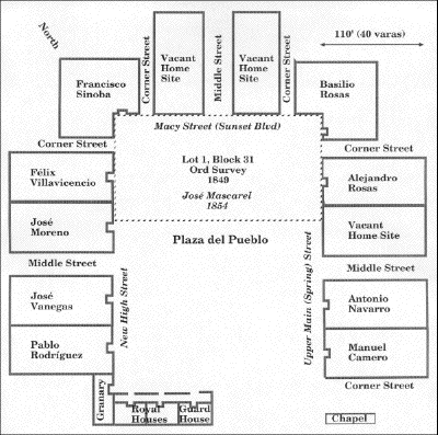
The old pueblo shown on the map above is given in more detail in plat given below, showing the approximate location of later streets and of lot 1 of block 31 from the 1849 Ord Survey.
The original 1786 diseño (map) from which the above plat was taken is reproduced below.[27]
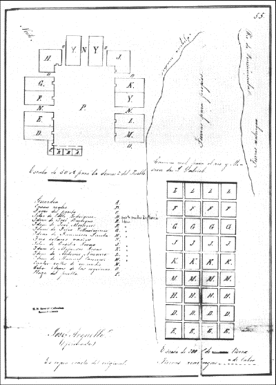
The Camino Real para el Rio y Mision de San Gabriel (the Highway between the River and the Mission of San Gabriel) ran from a location west of the pueblo southeast to the river and then to the mission. Today Aliso Street more or less follows the route of the old camino.
The farm lots to the southeast of the pueblo were separated from the town by about 100 varas (275 feet). They started 2,200 varas (1.15 miles) south of the dam at the junction of the zanja madre with the river,[28] the land in between being designated propios (municipal lands). The lots were between the zanja madre and the river, below the old camino, and were in nine rows of four lots each. Each lot measured 200 varas square (550 feet), the land required to plant one fanega (1.6 bushel) of seed corn. They were separated by three varas (eight feet), and each settler was allotted four lots.
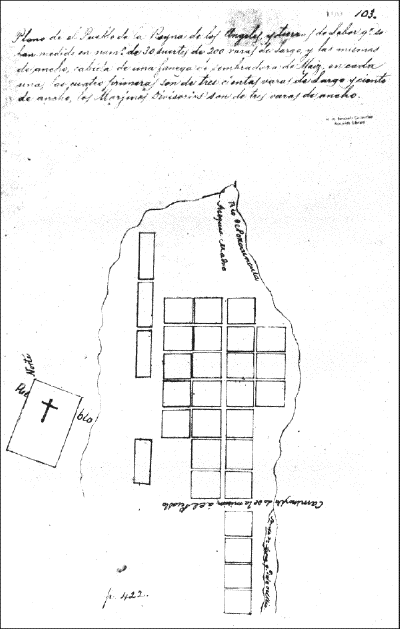
The discussion of the farm lots in the 1872 Directory, given earlier, notes a different number and layout of lots. The first map of the pueblo was made in 1781 prior to the final disposition of the lots as recorded on the 1786 map and was no doubt referred to by the authors of the discussion in the Directory. That first map is reproduced below and shows 22 lots (two per family), 200 varas square, north of the highway, as well as four other lots to the west measuring 100 varas by 300, and four lots, 200 varas square, south of the highway that were the beginning of the final layout.[29]
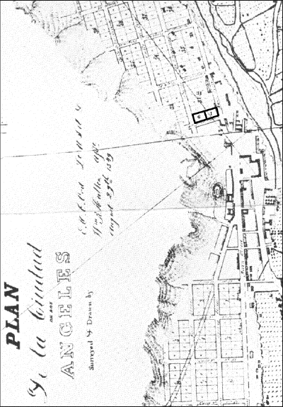
Harlow notes an item of evidence to support the location of the old pueblo as given above. The official minutes of the Common Council of the city for July 20th, 1850,[30] record that a Mr. Tomás Braun (Thomas Brown) wanted to build on land "which formerly was the Old Plaza." This land was on the southeast corner of Broadway and Sunset, part of lot 6 of block 31 in the Ord Survey, adjacent to the northwest side of lot 1. See the relevant portion of the Ord Survey reproduced below, where lots 6 and 1 have been outlined. While it appears that the old plaza occupied lot 1 (owned by José Mascarel in 1854), some of the homesites occupied lot 6, lending further credence to the probable location of the old pueblo.
At most, the Council minutes would indicate that the location may have been slightly northwest of the indicated location, crossing New High Street towards Broadway.
Rev. Adam's statement above about the location of the pueblo chapel at the southeast corner of Broadway and Sunset, on lot 6, could also explain the Council's reference to Mr. Braun's land as that "which formerly was the Old Plaza."
Logic also suggests that the different orientation of the streets north of the current plaza--North Broadway, New High, North Spring (Upper Main), Macy, Ord, Alpine, College, etc., extending into what is now Chinatown--and the consequent layout of that area on the 1849 Ord Survey derived from the orientation of the old plaza, other explanations lacking.
Up to 1810 the services at the old chapel were held under the auspices of the priests from the mission at San Gabriel. In that year the pueblo sought permission to build a new church and obtain its own priest. On August 15th, 1814, a cornerstone was laid at a site reportedly near the river and present-day Aliso Street. In January 1818 that site was abandoned due to floods[31] which seem to have changed the bed of the river to near what is now Alameda Street, and a new structure was begun in 1819 at the present site. It was completed and dedicated on December 8th, 1822. In time the open space in front of the new church became the de facto new plaza through common use and, form following function, the city's future growth re-oriented about that new public square. Harlow put it well:
. . . whatever remained of the old Plaza, with its crumbling walls, faded into the resorbent terrain. Few of the names, even, of the original inhabitants endured (Carmen Navarro, "a poor woman, advanced in years . . . one of the founders of the town," was still a householder in 1847). It was the new Plaza, then, that appeared on the first American survey of 1849; and its configuration of buildings and alleyways, rather than the original square, gave their prevailing directions to the streets of the emerging city.
An article by Mason and Duque[32] conjectured several sites for the first plaza, mostly to the south of the current plaza, and stated that it was not "in the oft-cited spot immediately to the northwest of the present Plaza":
The exact location of the first Los Angeles Plaza is a mystery. It does not appear to have been in its present location, nor was it in the often-cited spot immediately to the northwest of the present Plaza. A reference or two suggests an original site several blocks south of today's location, but there is no certainty of such a Plaza south of Fifth Street and east of San Pedro Street. Descriptions of 1789 and 1790 do state, however, that the little pueblo of that time was of easy access from all sides, suggesting that the Plaza of that time was not adjacent to Fort Moore Hill, as it was later.
Whatever the original location may have been, by the early 1800s the Plaza was probably near its present location, and may have been moved to higher ground during the 1790s in response to rampages of the Los Angeles River. A change in course [of the Los Angeles River] during the flood of 1815 promped another move [of the church] , with more substantial documentation, this time to a spot just northwest of today's Plaza. We know that the Plaza Church was moved to a place less exposed to flood on the recommendation of Governor Sola by 1818. It is not unusual for Mexican churches to flank, rather than face, the town square, and such would have been the case with the Plaza directly north of the church.
. . . An interesting and unresolved problem is the location of two adobes just north of East First Street between Main and Los Angeles Streets. These were the houses of Francisco Alvarado and Guillermo Cota. Both men were comisionados of the Pueblo. Alvarado served from 1795 to 1810, and Cota was his successor, serving from 1810 to 1818, and again for a short time later. A comisionado was a sort of Indian agent, police chief, military attaché, and pueblo manager. Why the comisionados' houses were so far from the town square is difficult to conjecture, unless the Plaza had been nearer to First and Los Angeles Streets at one time. A suggestion that the earlier site for the Plaza Church had been near Aliso and Alameda Streets, and that a pre-1815 Plaza had been there gains some credence with the comisionados' houses somewhat closer to a Plaza south of the present one.
Harlow responded to receipt of a copy of the article, sent to him by El Pueblo de Los Angeles State Historic Park, with a letter dated March 30th, 1986, to the Park[33] stating:
I much appreciate your taking the trouble to prepare for me a copy of Bill Mason's Terra Magazine article on the Plaza. It is a fine summary of information about the area.
I wonder only about his statements concerning the location of the first Plaza. There were, as I read the record, three church sites: the first, of 1784, at the south end of the "Old" Plaza; the second, where a cornerstone was laid in 1814 but no building was ever completed, closer to the River (perhaps on Alisal [Aliso]); and the present location, at which construction was begun in 1819, southeasterly of but near the original Plaza. [Of the first site, the] 1781 map of the pueblo (reproduced in Harlow, Maps of . . . Los Angeles, p. 9), as well as the one of 1786 (p. 11), show the Plaza west of and near the edge of the zanja madre, with the road to the mission below the Plaza's southern end (at what became Alisal [Aliso] Street, which led circuitously across the agricultural plots to San Gabriel). The bit of information in the city archives (see L. A. Maps, p. 14-15) about Thomas Brown's lot at the corner of Sunset and Broadway on land which, in 1850, was "formerly the Old Plaza" tends to corroborate this. The second site, subject to inundation and shifted to higher ground by the governor's order, is sometimes overlooked, confusing the relationship between the first and present sites.
It would be interesting to learn your views upon these and much more current matters relating to El Pueblo, and I shall call you about making a visit.
It is the author's opinion that, although the site of the original pueblo cannot be fixed with absolute certainty, the preponderance of evidence points to the approximate location which is shown again here.
This evidence is summarized below:
With regard to Mason and Duque's article stating that the first plaza was not "in the often-cited spot immediately to the northwest of the present Plaza," and referring to a couple of sites to the south of the current plaza, no evidence as concrete as that noted above is given in support. Further:
Bancroft, Hubert H. History of California. San Francisco: The History Company, 1886-90. Seven volumes.
Bonilla, Antonio. "Extracto do las representaciones del Coronel Dn. Phelipe Neve . . . ." February 23, 1780. Ms. 8, No. 1. (Archivo General de Indias, Guadalajara 271, Carpeta I; cited in the Chapman catalogue, entry 4104.)
Chapman, Charles E. Catalogue of materials in the Archivo General de Indias for the history of the Pacific coast and the American southwest. Berkeley: University of California Press, 1919.
Chapman, Charles E. A History of California: the Spanish period. New York: The Macmillan Co., 1928.
Croix, Teodoro de. Teodoro de Croix to José de Galvez, Arispe, February 28, 1782. Ms. (Archivo General de Indias, Guadalajara 267, no. 726; cited in the Chapman catalogue, entry 4058.) Report upon the founding of Los Angeles, September 4, 1781, with settlers recruited by Rivera; location, number of persons, distribution of animals and supplies.
"First census of Los Angeles, peninsula of California." Probably dated at San Gabriel, November 19, 1781. Ms. (Bancroft Library, Provincial state papers, Missions, and colonization, I: 101-02.) Translated in Annual Publication, Historical Society of Southern California, 1931, 15: 148-49.
Guinn, J. M. "The plan of old Los Angeles, and the story of its highways and byways." Annual Publication, Historical Society of Southern California, 1895, 3: 40-50. Notes the location of the old Plaza and the presumed origin of the new Plaza.
Neve, Felipe de. Felipe de Neve to Teodoro de Croix, San Gabriel, October 29, 1781. Regarding the quarantine of settlers, move to the site of the new pueblo, and the progress made there. Quoted in Temple, "Se fundaron . . . ," 87.
-----. "Instrucción para la fundación de los Angeles, 26 de Agosto, 1781." Ms. (Bancroft Library, State papers and colonization, I: 97.)
-----. "Reglamento é instuccion para los presidios de la peninsula de Californias . . .," June 1, 1779. Ms. (Bancroft Library.)
Newmark, Maurice H. and Marco R., editors. Sixty Years in Southern California, 1853-1913, Containing the Reminiscences of Harris Newmark. Fourth edition; Los Angeles: Zeitlin & Ver Brugge, 1970. Notes site of second church near Aliso Street and the river on p. 101.
Owen, Thomas. "The church by the Plaza, a history of the pueblo church of Los Angeles." The quarterly, Historical Society of Southern California 1960, 42:5-26, 186-204.
Paulou, Francisco. Historical memoirs of New California . . . . Edited by Herbert Eugene Bolton. Berkeley: University of California Press, 1926. Four volumes.
-----. Life of Ven. Padre Junipero Serra . . . translated by the Very Reverend J. Adam. San Francisco: 1884.
-----. Palou's Life of Fray Junipero Serra, Translated and annotated by Maynard J. Geiger. Washington, D. C.: Academy of American Franciscan History, 1955.
Proceedings of the Ayuntamiento and the background papers of that body and of the Common Council and the City Council from 1827. (In the "vault", City Clerk's Office, room 395, City Hall, 200 Spring Street.) Translations from the original Mss.
Proceedings of the Common Council, afterwards the City Council, from July 3, 1850, to date. (In the "vault", City Clerk's Office, room 395, City Hall, 200 Spring Street.) Translations from the original Mss.
Richman, Irving B. California under Spain and Mexico, 1537-1847 . . . . New York: Cooper Square Publishers, Inc., 1965. A facsimile reprint of the 1912 edition.
Temple, Thomas W., II. "Se fundaron un pueblo de Españoles." Annual Publication, Historical Society of Southern California, 1931, 15: 69-98.
-----. "Soldiers and settlers of the expedition of 1781." Annual Publication, Historical Society of Southern California, 1931, 15: 99-116.
Treuitlein, Theodore E. "Los Angeles, California: the question of the city's original Spanish name." Southern California quarterly, 1973, 55: 1-7.
Warner, J. J. An historical sketch of Los Angeles county, California, from the Spanish occupancy, by the founding of the Mission San Gabriel Archangel, September 8, 1771, to July 4, 1876. Prepared by J. J. Warner, Judge Benjamin Hayes, Dr. J. P. Widney. A reprint of the original edition . . . . Los Angeles: O. W. Smith, 1936. Notes the location of the old Plaza on pp. 20-21.
Layne refers to Temple with regard to old Mexican racial terms:[35]
The following notes on the races and castes of Mexico, which were prepared by Thomas Workman Temple, taken from Vol. II, p. 471, of Mexico a través de los Siglos, clear up some of the confusion:
- Español--Spaniard;
- Criollo--Child born in Mexico of Spanish parents;
- Mestizo or Coyote--Child of Spanish father and Indian mother;
- Castizo--Child of mestizo father and Spanish mother;
- Español--Child of castizo father and Spanish mother;
- Mulato--Child of Spanish father and Negro mother;
- Morizco--Child of Mulato father and Spanish mother;
- Salta-altras (literally a "throw-back")--Child with Negro characteristics but of white parents;
- Chino--Child of a salta-altras and an Indian;
- Lobo--Child of a chino and a mulata;
- Gibaro--Child of a lobo and a mulata;
- Albarrazado--Child of a gibaro and an Indian;
- Cambujo--Child of an albarrazado and a Negress;
- Zambo-prieto--Child of a cambujo and an Indian, or a Negro and a Zamba;
- Calpan Mulata--Child of a zambo and a mulata.
[1] Ward Ritchie, The First Los Angeles City and County Directory, 1872 (Los Angeles: The Ward Ritchie Press, 1963), 19-23.
[2] It contains a few errors which are corrected herein and/or in the next section.
[3] There is no evidence that any of the settlers had been soldiers.
[4] According to J. M. Guinn, "The Plan of Old Los Angeles and the Story of its Highways and Biways," Annual Publication, Historical Society of Southern California, Los Angeles (1890), 50, Antonio Miranda, chino, was "left behind at Loreto in Lower California . . . . There is no evidence that he ever joined the colonists at Los Angeles." He was not Chinese--in Mexico, a chino was generally a curly-haired half-breed (Indian and white).
[5] A vara is 33 inches in length.
[6] C. P. Campbell, 1 Upper Main Street, at the northeast corner of Marchessault Street.
[7] By 1786 36 fields were laid out southwest of the original 22 fields, as discussed later.
[8] They resided on the east side of the river, below the Downey Avenue viaduct.
[9] A toma is an irrigation ditch.
[10] The second Rodriguez was actually Antonio Miranda, the chino.
[11] That is, the city covered a bit more than four square Spanish leagues. A linear Spanish league is 2.635 miles, and a square Spanish league is just under seven square miles.
[12] Neal Harlow, Maps and Surveys of The Pueblo Lands of Los Angeles (Los Angeles: Dawson's Book Shop, 1976), 1-16. The chapter is titled "Los Angeles, The New Pueblo, 1781-1786."
[13] The corporal and the three soldiers present at the founding were a part of the new town but received no land.
[14] An Ensign was an army rank just below lieutenant, about equivalent to today's second lieutenant.
[15] About ten and a half miles.
[16] Fr. Francisco Palóu, Relacion Historica de la Vida y Apostolicas Tareas del Venerable Padre Fray Junipero Serra, 1787, 243, gives a brief record of the founding:
"Interin dispuso la fundacion de un Pueblo de Españoles en el Rio de Porciúncula, llamado por la primera Expedicion del Año 1769. Juntó todas los Vecinos Pobladores que habian venido para Colonos,les señaló sitio y tierras en las orillas del Rio distante de la Misión de San Gabriel quatro leguas rumbo al Noroeste [emphasis added], y alli Escoltados de un Cabo y tres Soldados, fundaron su Pueblo á últimos del año de 81 con el título de Ntr€. Señora de los Angeles de Porciúncula, en el que se mantienen de sus siembras &c. como queda dicho del Pueblo de San Joseph en su Capítulo, aunque con el trabajo de haber de andar quatro leguas para oir Misa."
[17] The three other families are accounted for as follows:
Miguel Villa and Rafael Mesa deserted before the end of the trip.
As noted earlier, Antonio Miranda, Chino, Hombre, 50, with a Niña, 11, was apparently left behind at Loreto, Baja California, with his daughter. He was not present at the founding, nor later.
Chino literally means Chinese, but generally refers to someone who has Oriental features, particularly around the eyes. Roy Rogers is an example of someone who might be described as chino. In the context of the 18th century, it referred to a child of a Spanish father, who had Negroid characteristics, and an Indian mother.
[18] This census is replicated on the Pobladores' plaque on south side of the present plaza.
A Mestizo or Mestiza is defined as a child of a Spanish father and an Indian mother.
A Mulato or Mulata is a child of a Spanish father and a Negro mother.
See the Appendix for a more extensive list of 18th-century racial terms in old Mexico.
[19] Through the 20th century, when anyone with any black heritage was considered black (such as a Mulato), and counting half-Indian (Mestizo) as Indian, the racial makeup of the original adult settlers would have been: 10 black (45.5%), 10 Indian (45.5%) and 2 white (9%). (In the 18th century, one could be counted white (Español) if no more than one-eighth Indian. )
The U. S. Federal Census of 2000 officially changes the racial classifications to permit multiple designations of heritage.
[20] Three of the eleven settlers--José de Lara, Antonio Mesa and Luis Quintero--were expelled as early as 1782 for being "useless to the pueblo and themselves," and did not appear on the pueblo plat given later. Of the eight remaining settlers, Alejandro Rosas disappeared by 1790 and José Antonio Navarro was expelled by 1800.
[21] José Sinoba arrived in 1785, was granted the same privileges as the original settlers and did appear on the 1786 plat, making a total of nine families assigned homesites and farm tracts on that plat.
[22] Harlow, Maps and Surveys of the Pueblo Lands, 1-16.
[23] However, the old sidewalks along the buried portion of Upper Main (later Spring), as well as along Short Street (old Sunset), are still visible today within the asphalt paving of the parking lot.
[24] Col. J. J. Warner, Judge Benjamin Hayes, Dr. J. P. Widney, An Historical Sketch of Los Angeles County, California, from the Spanish Occupancy, by the Founding of the Mission San Gabriel Archangel, September 8, 1771, to July 4, 1876 (Los Angeles: Louis Lewin & Co., 1876), 21. The book was reprinted in Los Angeles by O. W. Smith in 1936. A similar and probably derivative description of the site is given in Guinn, "The Plan of Old Los Angeles . . . ," 41-42.
[25] Measuring from the original 1786 map of the pueblo, the dimensions were close to that, about 80 varas by 110 (220 feet by 300) when measured from homesite-to-homesite in width and from homesite-to-guard house in depth.
[26] Rev. Jose Adam, Vicar General, "History of the Catholic Church in Los Angeles County," Annual Publication, Historical Society of Southern California, Los Angeles (1890), 25.
However, in the next paragraph, Rev. Adam incorrectly states that the present church was built between 1812 and 1815, casting some doubt on his accuracy. The cornerstone of a new church near the river was laid in 1814, but that site was abandoned in 1818. The construction of the church at the present site was begun in 1819 and it was dedicated in 1822.
[27] Harlow, Maps and Surveys of the Pueblo Lands, 11. The map given in Harlow is taken from the California Archives, vol. 2 (Provincial State Papers, vol. 3): 55, in the Bancroft Library of the University of California, Berkeley. It is labeled "José Arguello. (firmado.) Es copia exacta del original."
[28] Near where Broadway now crosses the river.
[29] Harlow, Maps and Surveys of the Pueblo Lands, 9. The map given in Harlow is taken from the California Archives, vol. 52 (State Papers, Missions and Colonization, 1): 103, in the Bancroft Library of the University of California, Berkeley. It is titled "Plano de el Pueblo de la Reyna de los Angeles y tierras de Labor qe. se han medido en numo. de 30 suertes de 200 varas de Lago, y las mismas de ancho, cabida de una fanega de sembradura de Maiz, en cada una; las quatro primeras son de tres cientas varas de Largo y ciento de ancho, los Marjines Divisorios son de tres varas de ancho." It is filed in the archives immediately following the Padrón of November 19th, 1781.
[30] In 1850, the location of the original pueblo would have been within the recollection of some of the older inhabitants of Los Angeles.
[31] Guinn, J. M., "Exceptional Years. A History of California Floods and Drought," Annual Publication, Historical Society of Southern California, Los Angeles (1890), 33-34: "In 1815 occurred a great flood that materially changed the course of the Los Angeles River within the city limits. The river abandoned its former channel and flowed west of the suertes or planting fields of the first settler, its new channel followed very nearly the present line of Alameda Street. The old fields were washed away or covered with sand, and new fields were located in what is now the neighborhood of San Pedro Street. In 1825 it again left its bed and drifted to the eastward, forming its present channel." Guinn's paper was read on March 4th, 1889.
[32] William Mason and Jeanne Duque, "Los Angeles Plaza, Living Symbol of Our Past," Terra, The Natural History Magazine of the West, Vol. 19, No. 3 (Winter 1981): 15-16.
[33] Courtesy of Mrs. Jean Bruce Pool, Historic Museum Director.
[34] Note that grading in the twentieth century extended the gentleness of the slope north past Broadway.
[35] J. Gregg Layne, Annals of Los Angeles, From the Arrival of the First White Men to the Civil War, 1769-1861, Special Publication Number Nine (San Francisco: California Historical Society, 1935), 89, footnote 6. Bullets and paragraphing have been added.